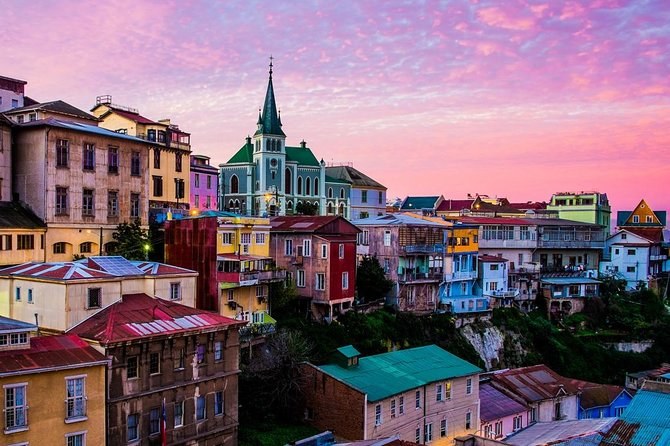
Famous Valparaíso! Premium Walking Tour with a Native Guide
Three hours on foot through the UNESCO quarter, both funicular tickets in the fare.
From $40 per person
Check AvailabilityValparaiso is built as an amphitheatre: a narrow flat strip along the water and more than forty hills stacked behind it. Knowing which cerro holds what saves a day of climbing the wrong staircase, and every guided route through them is set out with city tour valparaiso chile.
The eight below are the ones you will actually meet. Each entry tells you what is up there, how you get up it, and how much of your day it is worth.
This is the hill you will mean when you say afterwards that you loved Valparaiso. Paseo Yugoslavo runs along its edge with the bay below it, Palacio Baburizza sits on the promenade at number 176, and the streets behind are galleries, small hotels and restaurants. The murals here are the photographed ones.
Getting up: Ascensor El Peral from Plaza Sotomayor, about a minute. Worth: two hours on foot, longer with the museum.
You cross to Alegre's twin over one footbridge, and it holds the older story of the two: the first ascensor in the city opened here on 1 December 1883. Paseo Gervasoni and Paseo Atkinson are its two promenades, the Lutheran church tower is its landmark, and the alleys between them are where the immigrant merchant families built.
Getting up: Ascensor Reina Victoria, built in 1902. Worth: an hour, and it runs straight into Cerro Alegre.
Come here for street art with a plan behind it. The Museo a Cielo Abierto is a set of murals by named Chilean artists laid out along the stairways, and La Sebastiana, Pablo Neruda's Valparaiso house, stands above it at Ferrari 692 with the whole bay out of its windows.
Getting up: on foot from Avenida Alemania, or by taxi if the stairs are too much. Worth: ninety minutes, plus an hour inside the house.
Sea level, and the oldest part of the city. Plaza Sotomayor with its monument to the heroes of Iquique, the naval command building, Muelle Prat where the harbour launches leave, and Iglesia La Matriz a few streets inland. It is a working quarter rather than a pretty one, and it is where almost every walking tour will collect you.
Getting there: flat, five minutes from the passenger terminal. Worth: an hour, and better with a guide.
The flat ground east of the port, and the part of Valparaiso that is simply a Chilean city. The National Congress has sat here since the 1990s, the coach terminal is on Avenida Pedro Montt at 2860, and the Mercado El Cardonal is the produce market the seven-hour walking tour uses.
Getting there: the metro along the bay, or a trolleybus. Worth: an hour, mostly for the market.
You will have this one largely to yourself, and it holds the oddity among the lifts: Ascensor Polanco, built between 1913 and 1915 by Easton Lift Co., is the only one that runs vertically inside a shaft rather than up a slope, and it was declared a monument in 1976. The hill holds an annual mural festival and a great deal of ordinary life.
Getting up: the lift itself, when it is running. Worth: an hour, with a guide who knows the streets.
The broad hill at the western end, above the port entrance. The university is up here, the football stadium too, and the view back across the whole amphitheatre is the one that explains the city's shape better than any map. Few tours climb it, which is part of why you should.
Getting up: trolleybus or taxi; the walk is long. Worth: forty minutes for the view.
Above the western end of the port, reached by Ascensor Artillería, which was built in 1892 as the third lift in the city and reopened on 31 October 1914 after an extension. Paseo 21 de Mayo runs along the top, with the Museo Naval y Marítimo behind it and the container terminal spread out below.
Getting up: Ascensor Artillería from Plaza Aduana. Worth: an hour, best in the last light.
The guided walks cover Alegre and Concepción in three hours; the longer days add the markets, Barrio Puerto and the port.
| Hill or quarter | Go for | How you get up | Allow |
|---|---|---|---|
| Cerro Alegre | Paseos, galleries, Palacio Baburizza | Ascensor El Peral | 2 hours |
| Cerro Concepción | The 1883 funicular, Gervasoni, Atkinson | Ascensor Reina Victoria | 1 hour |
| Cerro Bellavista | The open-air museum, La Sebastiana | On foot or by taxi | 1.5 hours |
| Barrio Puerto | Plaza Sotomayor, Muelle Prat, the port | Flat | 1 hour |
| El Almendral | Congress, the market, the coach terminal | Metro or trolleybus | 1 hour |
| Cerro Polanco | The vertical lift, the mural festival | Ascensor Polanco | 1 hour |
| Playa Ancha | The view back over the whole bay | Trolleybus or taxi | 40 minutes |
| Cerro Artillería | Paseo 21 de Mayo, the naval museum | Ascensor Artillería | 1 hour |
See which tours walk which hills
The hills themselves are not a ticketed attraction, so the sources here are the bodies that list the lifts and the museums on them.
Three hours on foot through the UNESCO quarter, both funicular tickets in the fare.
From $40 per person
Check Availability
Seven hours on trains, trolleybuses and funiculars, through the markets and over both cerros.
From $80 per person
Check Availability
The lifts rather than the stairs: three and a half hours, and step-free by its operator.
From $40 per person
Check AvailabilityWhat to do once you are up there is on things to do, how to reach the city on getting there, and every guided route through the cerros on Valparaiso Tours.